Knowledge Exchange, Spatial Analysis and Healthy Urban Environments
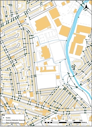
KESUE is a 12 month project that aims to take existing academic research on measuring the walkability of the built environment and seek applications in the real world. As part of the PARC Study a GIS based network of all the footpaths in East Belfast (the Real Walkable Network, RWN) was created. Using Network Analysis areas of poor pedestrian access can be investigated. In addition to this, the RWN can help identify priorities for promoting increased physical activity as well as a range of other uses.
The KESUE project aims to extend the RWN across the whole of the Belfast while creating a new network in the Derry City Council areas while working work with the project partners to explore the ways in which this can be developed as a tool for supporting policy and service delivery in a range of areas. Such applications are thought to include but not cease at the management of open space, active travel, regeneration and accessibility studies for the delivery of council services such as leisure centres.
Project Aims
- Develop the Real Walkability Network (RWN) and associated walkability model as a policy-support tool for increasing physical activity in the cities of Belfast and Derry, including expanding the coverage of detailed elements of the GIS tool to encompass both these local authority areas;
- Further develop the analytical functions of the walkability model and associated data to align with specific council initiatives, including improved park management, increased connectivity, promoting "shared space" and prioritising infrastructure investment for physical activity;
- Develop an evidence base of built environment attributes in Derry and Belfast that can contribute directly to the delivery of strategies for physical activity, including the NI Obesity Strategy, the Cardiovascular Service Framework, the forthcoming Active Travel Strategy and the forthcoming Regional Transportation Strategy;
- Provide direct training to local government officers in Belfast and Derry City Council so they are able to integrate and expand the use of the tool as a sustainable part of the councils' activities;
- Identify further opportunities for implementing the walkability tool in other settlements across Northern Ireland.
- Disseminate the use of GIS-based walkability tools in other UK cities as a decision-support tool for promoting physical activity.

The KESUE project is funded under the Economic and Social Research Council’s Knowledge Exchange programme (Grant No.ES/J010588/1) with additional support from the Department of Regional Development (NI), Belfast City Council, Derry-Londonderry City Council, Public Health Agency and Belfast Healthy Cities