Background
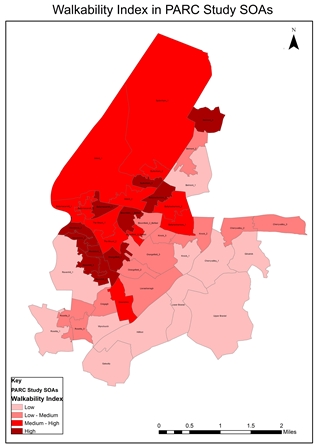
This images shows a GIS based composite Walkability Index calculated for the PARC Study area.
The KESUE Project has its roots in the Physical Activity and Rejuvination of Connswater (PARC) Study. As part of the PARC Study, the Built Environment Working Group created a GIS-based Walkability index. To measure one of the elements of this composite index, a very detailed pedestrian network was created, replacing the commonly used Road Centre Line. In addition to contributing to the Walkability Index, it was found that this network could be applied to measure pedestrian accessibility to any mapped service in the survey area.